
Photogrammetry is the science and art of obtaining reliable three-dimensional measurements, coordinates, and maps of physical objects and terrain from overlapping two-dimensional photographs. Originating in the mid-nineteenth century shortly after the invention of photography, photogrammetry revolutionized cartography during the twentieth century through analog and analytical stereo-plotting instruments. Today, it drives rapid 3D digitization across satellites, manned aircraft, unmanned aerial drones, and close-range terrestrial cameras. By mathematically reconstructing the exact position and orientation of a camera at the moment each image was captured, photogrammetric surveying converts flat photographic pixels into metric-grade spatial intelligence.
Fundamental Geometry: Stereoscopy and Collinearity
The mathematical backbone of photogrammetry rests on central perspective projection and stereoscopic parallax. When a camera captures a photograph, light rays travel from ground features through the camera’s optical perspective center onto the digital sensor. While a single 2D photograph records angular directions to objects, it cannot directly reveal distance (depth) without additional geometric constraints.
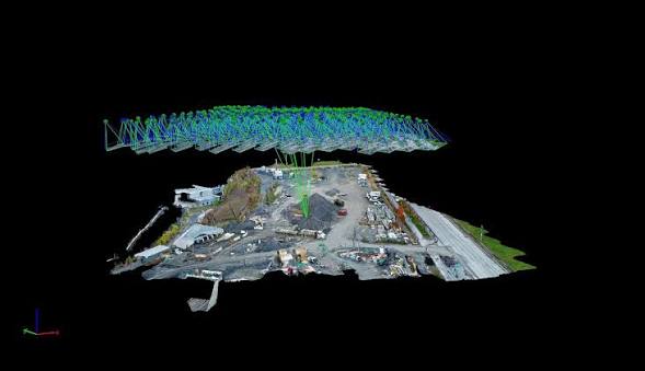
When two or more photographs capture the same ground area from different camera stations—typically with 60% to 80% forward overlap along a flight line and 60% to 75% side overlap between adjacent flight strips—light rays from both camera centers intersect at the exact 3D ground coordinate of every visible feature. In mathematical photogrammetry, this relationship is governed by the collinearity equations, which state that the exposure station, the image point on the sensor, and the corresponding ground object point all lie along a single straight line in 3D space.
Modern Structure-from-Motion (SfM) and Bundle Block Adjustment
Traditional analytical photogrammetry required meticulously calibrated metric cameras and human operators viewing stereo pairs through optical-mechanical instruments to trace contour lines manually. Today, modern digital photogrammetry combines Structure-from-Motion (SfM) computer vision algorithms with rigorous photogrammetric Bundle Block Adjustment:
- Automated Feature Matching: Advanced software scans hundreds or thousands of overlapping images to detect millions of distinctive visual keypoints (corners, edges, and texture gradients) that remain recognizable despite changes in viewing angle, lighting, or scale.
- Self-Calibrating Bundle Adjustment: Using matched tie points across overlapping photos, the algorithm simultaneously solves for the exterior orientation parameters (X, Y, Z coordinates plus roll, pitch, and yaw rotation angles) of every camera exposure and refines interior camera lens calibration parameters (such as focal length, principal point offset, and radial/tangential lens distortion).
- Ground Control Points (GCPs) and RTK/PPK Georeferencing: While relative geometric models can be reconstructed from images alone, anchoring the model to real-world map datums requires surveyed Ground Control Points—high-contrast targets placed on the ground whose coordinates are measured via RTK-GNSS or total station—or onboard Post-Processed Kinematic (PPK) GNSS receivers that tag every shutter click to centimeter accuracy.
- Dense Multi-View Stereo (MVS) Matching: Once camera positions and orientations are locked in, dense matching algorithms compute 3D coordinates for nearly every pixel across the image overlap zones, generating dense colorized point clouds, textured 3D polygonal meshes, Digital Surface Models (DSMs), and true orthomosaics.
Key Photogrammetric Deliverables
Photogrammetric processing pipelines yield a diverse suite of high-precision spatial products:
- True Orthomosaic: Unlike a raw aerial photograph—which suffers from perspective tilt, lens distortion, and topographic relief displacement (making tall buildings appear to lean outward from the center)—an orthomosaic is differentially rectified pixel-by-pixel using the underlying 3D surface model. The result is a uniform-scale, map-accurate aerial image on which engineers can measure true horizontal distances directly.
- Digital Elevation Models (DEM/DSM/DTM): Raster elevation grids representing either the full reflective surface including rooftops and tree canopies (DSM) or filtered bare-earth terrain (DTM).
- Textured 3D Reality Meshes: Photorealistic polygonal models draped with high-resolution imagery, ideal for architectural visualization, line-of-sight analysis, and virtual site inspections.
Versatile Applications Across Scales
Photogrammetric surveying spans an extraordinary range of spatial scales and industries:
- Large-Area Corridor and Regional Mapping: Manned aircraft equipped with large-format metric cameras map entire metropolitan regions, agricultural watersheds, and national highway networks in a single flying season.
- Close-Range Industrial and Architectural Photogrammetry: Handheld DSLR cameras or multi-camera rigs measure structural deformations in bridge girders, inspect wind turbine blades, document historic architectural facades stone-by-stone, and verify industrial manufacturing tolerances to sub-millimeter precision.
- Satellite Stereo Photogrammetry: Commercial Earth-observation satellites capture high-resolution stereo triplets from orbit, generating digital terrain models over remote mountain ranges, disaster zones, and conflict areas inaccessible to ground survey crews.
Strengths and Limitations
Photogrammetry excels at capturing rich visual context, true-color textures, and crisp edges across sunlit, well-textured surfaces at high speed and modest equipment cost. However, because it relies on passive optical light, photogrammetry cannot penetrate dense forest canopies to see the bare ground beneath, struggles on uniform featureless surfaces (such as fresh snow, calm water bodies, or blank white walls), and degrades in heavy shadows or low-light conditions—scenarios where active laser scanning (LiDAR) serves as its natural technological complement.